Students of architecture and town planning in India, are familiar with the name of Le Corbusier, who designed the planned city of Chandigarh. But it is quite unlikely that they would have heard of Kempegowda, or maybe would have heard of him as some local, sundry chieftain from the south.
This post is about why Kempegowda is so revered in Bengaluru and the science behind his founding of the town that is now India's tech capital.
Kempegowda was a regional chieftain (ಪಾಳೇಗಾರ) under the Vijayanagar empire that was headquartered in Hampe (known as Hampi, to the outside world). He is widely regarded as the founder of present-day form of Bengaluru, but very few people know why this is so.
Bengaluru is situated on top of the Deccan plateau, and is about 3000ft above sea level. It literally sits on hard, igneous rock, and was historically known for its white granite. The name of the town literally comes from the white granite (ಬೆಂಗಲ್ಲು) that is found here. The name of the town has nothing whatsoever to do with boiled beans. A similar town near present day Chennapattana called Kengal (ಕೆಂಗಲ್ಲು) was known for its black granite.
These areas had no natural source of water like a big river or the sea coast. It was far away from the coast, and high up in the Deccan plateau. The nearest major river was Cauvery, almost a 100km away. Nevertheless, the demand for granite from different parts of the kingdom had made Bengaluru into a thriving trading hub under the Western Ganga dynasty up until 1000 CE, and under the Chola Empire later on. The story of Bengaluru goes back far into history. Ancient Roman coins have been found in Bengaluru, and not just that, in Talakadu on the banks of the Cauvery, archeologists even found a mould for minting Roman coins! Talk about counterfeiting!
Kempegowda had recognised the importance of Bengaluru as a trading hub, and proceeded to build a planned township around several markets called Petes (ಪೇಟೆ). In 1537, he built a fort with eight gates to the town, with a moat surrounding it. Only small parts of the Bengaluru fort remain standing to this day, near the K R Market area.
Inside the fort were several marketplaces or Petes: Balepete, Akkipete, Chikkapete, Nagarathpete, Ragipete, Arelepete, etc. all of which exist to this day as localities in the city. The entire town was designed around marketplaces. On a related note, the cosmopolitan nature of Bangalore is not a post IT boom phenomenon, as is widely believed. It was not even the British Cantonment that brought diversity to the place. The town was a trading hub from much further ago.
The township within the fort was demarcated into blocks (called Agrahara) and were allocated explicitly for residential and business areas. Most roads in the town ran from East to West, or from North to South. This practice continues to this day. People interested in city planning often find this curious property about Bangalore roads -- some narrow roads are called "mains" and some big roads are called "cross". The names "main" and "cross" does not refer to the size of the roads in Bengaluru -- but to whether they are a East-West road, or a North-South road.
The main challenge for Kempegowda was to provide water supply to the capital city of his province. As noted earlier, there are no major rivers or the coast nearby.
In order to cater to the city's water needs, Kempegowda surveyed a much bigger area starting from Hesaraghatta in the north, to Begur in the south, and studied rainfall patterns and lakes in the area. He then constructed a vast network of lakes and feeder canals between the lakes, to connect almost 1000 lakes in an intricate pattern of canals. These feeder canals were called Rajakaluve (ರಾಜಕಾಲುವೆ) or "main canals" that were not to be disturbed. They were critical to ensure not just water supply to the lakes, but also to form a continuous system of flow, so that the lakes remained fresh.
This approach to planned cities based on principles of Vastushastra, is very different from what present day students study about town planning -- that involves concerns like design of public spaces, creating central business districts, paved roads, footpaths, etc. All of these are important, but they come much later. The provision of a near continuous source of fresh water to a landlocked town, is architectural design at a much more fundamental level.
Kempegowda also knew that this network of lakes cannot sustain a large population. He then estimated how the city would grow, and created markers in the forests outside of the city until which the city could grow comfortably with the designed network of 1000 lakes. These markers are called "Kempegowda towers" today -- of which only 3 of 4 towers are remaining.
Today all four Kempegowda towers are within the city limits, and the city has grown far beyond the four towers.
The citizens of the town organised a grand festival to celebrate his return where they put him on a swing (Uyyale ಉಯ್ಯಾಲೆ) as part of the celebration. The area came to be known as Uyyale-kavalu, which in the present day is known by the Anglicised name Vyalikaval, near Sadashivanagar, that is home to several celebrities and political leaders.
This post is about why Kempegowda is so revered in Bengaluru and the science behind his founding of the town that is now India's tech capital.
Kempegowda was a regional chieftain (ಪಾಳೇಗಾರ) under the Vijayanagar empire that was headquartered in Hampe (known as Hampi, to the outside world). He is widely regarded as the founder of present-day form of Bengaluru, but very few people know why this is so.
Bengaluru is situated on top of the Deccan plateau, and is about 3000ft above sea level. It literally sits on hard, igneous rock, and was historically known for its white granite. The name of the town literally comes from the white granite (ಬೆಂಗಲ್ಲು) that is found here. The name of the town has nothing whatsoever to do with boiled beans. A similar town near present day Chennapattana called Kengal (ಕೆಂಗಲ್ಲು) was known for its black granite.
These areas had no natural source of water like a big river or the sea coast. It was far away from the coast, and high up in the Deccan plateau. The nearest major river was Cauvery, almost a 100km away. Nevertheless, the demand for granite from different parts of the kingdom had made Bengaluru into a thriving trading hub under the Western Ganga dynasty up until 1000 CE, and under the Chola Empire later on. The story of Bengaluru goes back far into history. Ancient Roman coins have been found in Bengaluru, and not just that, in Talakadu on the banks of the Cauvery, archeologists even found a mould for minting Roman coins! Talk about counterfeiting!
Kempegowda had recognised the importance of Bengaluru as a trading hub, and proceeded to build a planned township around several markets called Petes (ಪೇಟೆ). In 1537, he built a fort with eight gates to the town, with a moat surrounding it. Only small parts of the Bengaluru fort remain standing to this day, near the K R Market area.
 |
| Bengaluru Fort. Image Source: Wikipedia. By Indrajit Roy - Own work, CC BY-SA 3.0, https://commons.wikimedia.org/w/index.php?curid=28760709 |
The township within the fort was demarcated into blocks (called Agrahara) and were allocated explicitly for residential and business areas. Most roads in the town ran from East to West, or from North to South. This practice continues to this day. People interested in city planning often find this curious property about Bangalore roads -- some narrow roads are called "mains" and some big roads are called "cross". The names "main" and "cross" does not refer to the size of the roads in Bengaluru -- but to whether they are a East-West road, or a North-South road.
The main challenge for Kempegowda was to provide water supply to the capital city of his province. As noted earlier, there are no major rivers or the coast nearby.
In order to cater to the city's water needs, Kempegowda surveyed a much bigger area starting from Hesaraghatta in the north, to Begur in the south, and studied rainfall patterns and lakes in the area. He then constructed a vast network of lakes and feeder canals between the lakes, to connect almost 1000 lakes in an intricate pattern of canals. These feeder canals were called Rajakaluve (ರಾಜಕಾಲುವೆ) or "main canals" that were not to be disturbed. They were critical to ensure not just water supply to the lakes, but also to form a continuous system of flow, so that the lakes remained fresh.
This approach to planned cities based on principles of Vastushastra, is very different from what present day students study about town planning -- that involves concerns like design of public spaces, creating central business districts, paved roads, footpaths, etc. All of these are important, but they come much later. The provision of a near continuous source of fresh water to a landlocked town, is architectural design at a much more fundamental level.
Kempegowda also knew that this network of lakes cannot sustain a large population. He then estimated how the city would grow, and created markers in the forests outside of the city until which the city could grow comfortably with the designed network of 1000 lakes. These markers are called "Kempegowda towers" today -- of which only 3 of 4 towers are remaining.
 |
| Kempegowda north tower at Mehkri circle. Image source: Karnataka.com |
At the time Kempegowda built his capital, its population was estimated to be about 500,000 and the larger area till the Kempegowda towers could sustain a population of about 1 million. And today, with a population of almost 11 million, the Bengaluru metropolitan area has only 29 of the 1000 lakes remaining! Many of the Rajakaluves have been encroached upon by roads and buildings, leading to major flooding during rains and dying down of lakes.
Today a major source of water supply to the city is from the Cauvery river which still remains where it was -- 100km away and 600 feet below in altitude. The daily electricity bill of pumping up water from the Cauvery is almost 1 crore rupees!
Following the industrial revolution (in Europe) and the semi-industrialisation of our colonised society, there has been a fascination for constructing large, non-local solutions to address local problems. Hence water supply for Bangalore was designed to come from somewhere far away. But what about the people and the ecosystem who already depended on the water over there?
When we construct a large infrastructure to solve a local issue, we in turn disrupt the ecosystem around the places where we source our materials from. This in turn causes a migration in search of jobs and business opportunities, into the urban centres that have large infrastructure built for them. This increases the demand for even more infrastructure, thus starting a vicious cycle of infrastructure building, disruption of existing ecosystems, and large inflow into urban centres.
In contrast to this, the Vastushastra approach to architecture and town planning, emphasises on extensively studying the structure and dynamics of the surrounding ecosystem (called the Vidhi), and make minimal, sustainable changes to the existing ecosystem so as to cater to our needs (the principle of dharma). The system that we build should be in harmony with the surroundings and form an overall stable ecosystem.
For some reason, Kempegowda is never regarded as a master architect in our mainstream education, and is never featured in any college syllabus on architecture and city planning (as far as I know that is, I would be glad to be proven wrong on this). Vastushastra is not studied as part of architecture or civil engineering curriculum either (as far as I know).
*~*~*~*~*~*
Coming back to the story of Kempegowda, such was his popularity among his people, that many neighbouring provinces started feeling insecure, and even worried that his popularity would become more than the kings at Vijayanagar itself.
The chieftain of Chennapattana, Jagadevaraya filed a false case against Kempegowda with the Vijayanagar king, alleging that he was minting coins illegally. This caused the king to imprison Kempegowda and take over Bengaluru town.
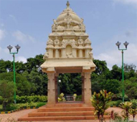
But the citizens of the town fought for him and finally convinced the king to drop the false case against him, after five years. After his release, Kempegowda constructed an underground cave temple near Basavanagudi called Gavi Gangadhareshwara temple as a thanksgiving to the divine.
 |
| Gavi Gangadherashwara cave temple at Gavipuram near Basavanagudi. Image source: Wikipedia. By Pavithrah - Own work, CC BY-SA 3.0, https://commons.wikimedia.org/w/index.php?curid=20746521 |


No comments:
Post a Comment